 |
Atlantic Ocean Hydrothermal FieldsГидротермальное оруденение Атлантического океанаLaboratory of Geomorphology and Ocean Floor Tectonicsof Geological Institute, Russian Academy of Sciences. |
Для русскоговорящих исследователей
25
лет назад в Галапагосском рифте американскими исследователями
было открыто первое гидротермальное поле на дне Мирового океана (http://www.divediscover.whoi.edu/).
Подобные объекты известны сейчас во всех океанах и в ряде окраинных морей.
Вместе с тем, все открытия имели случайный характер
и примером может быть исследования на угловом поднятии разлома Атлантис
(http://www.nsf.gov/od/lpa/news/, Ridge Events, Newsletter of the US RIDGE
InitiativeRidge Inter-Disciplinary Global Experiments, Vol. 11, № 2, June
2001, http://earthguide.ucsd.edu/mar/ ).
Ниже Вы можете прочитать наши статьи (тексты и иллюстрации
по отношению к оригиналам несколько изменены), которые были направлены
на разработку прогноза положения "черных курильщиков" и рудной минерализации
в Атлантическом океане.
Неточности, которые мы нашли в некоторых ранее опубликованных
рисунках оригиналов статей - не исправлялись. Приносим
за них извенения читателям.
25 years ago in
Galapagos rift american researchers descovered first oceanic bottom hydrothermal
field (http://www.divediscover.whoi.edu/). Today we known these phenomens
in all oceans and in any marginal seas. Unfortunatally all discoveries
was случайный характер. As exampele - divings on the Atlantis FZ High Inside
Corner (http://www.nsf.gov/od/lpa/news/, Newsletter of the US RIDGE
Initiative, Ridge Events,
http://earthguide.ucsd.edu/mar/,
Ridge Inter-Disciplinary Global Experiments, V. 11, # 2, 2001).
Мы помещаем наши статьи (тексты
и иллюстрации несколько изменены), которые были направлены на разработку
прогноза положения "черных курильщиков" и рудной минерализации в Атлантическом
океане.
Опечатки, которые мы нашли в
оригиналах статей - не снимались. Приносим
за них извенения читателям.
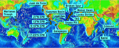
Положение активных гидротермальных полей
Active hydrothrmal fields location
“The Discovery of Hydrothermal Vents - 25th Anniversary CD-ROM”
©2002 Woods Hole Oceanographic Institution
1998 Тектоническое положение
гидротермальных полей на Срединно-Атлантическом хребте
2001 Гидротермальная
минерализация разлома Сьерра-Леоне (Центральная Атлантика)
2002 Положение и перспективы
открытия гидротермальных полей в Срединно-Атлантическом хребте
1998 Mid-Atlantic Ridge
Hydrothermal Fields Tectonic Position
2001 Sierra Leone Fracture
Zone Hydrothermal Mineralization (Central Atlantic Ocean)
2002Mid-Atlantic
Ridge Hydrothermal Fields: Setting and Further Discoveries Prospects
Гидротермальное
оруденение Атлантического океана
ТЕОРЕТИЧЕСКАЯ МОДЕЛЬ
Литология и полезные ископаемые. 1998. № 4.
С. 436-439
Тектоническое положение гидротермальных полей на Срединно-Атлантическом хребте
А.О. Мазарович, С.Ю. Соколов
АННОТАЦИЯ
Положение гидротермальных полей в Срединно-Атлантическом хребте было
сопоставлено с гравитационными аномалиями и положением эпицентров землетрясений
(1937-1997). Установлено, что гидротермальные поля тяготеют к относительно
стабильным (асейсмичным) частям рифтовых зон, которые наиболее благоприятны
для устойчивой циркуляции растворов в условиях спрединга с низкими скоростями.
Такие области располагаются в областях разрывов ("discontinuty").
В Лаборатории геоморфологии и тектоники дна океанов Геологического
института РАН проводится работа над созданием цифровой тектонической карты
Центральной Атлантики. Она сопровождается созданием базы данных и анализом
самого разнообразного материала. В ходе этих исследований у авторов появились
наблюдения, которые, возможно, представят интерес для специалистов в области
океанских гидротермальных систем.
Высокотемпературные гидротермальные источники были открыты в конце
семидесятых годов. В настоящий момент в Мировом океане изучено с разной
степенью детальности свыше 100 активных и реликтовых полей [Rona, Scott,
1993].
Региональные исследования [Рона, 1986, Rona, Scott, 1993 и др.]
показали, что большинство гидротермальных рудопроявлений расположено в
пределах неовулканических зон рифтов (ТАГ, Снейк Пит и Брокен Спур) и тяготеют
к вулканическим сводам в их пределах. Отмечено, что активные гидротермальные
источники чаще всего размещаются в зонах тектонических нарушений. Известна
ситуация, когда активное гидротермальное поле ("Логачев") располагается
на поверхности краевого уступа рифтовой долины, сложенного серпентинизированными
ультраосновными породами [Богданов и др., 1995]. Такое положение
плохо вписывается в существующую схему циркуляционных гидротермальных
систем спрединговых хребтов.
При составлении карты магматизма Центральной Атлантики появилась
идея отразить на ней и положение гидротермальных полей. После того
как они были вынесены на карту гравитационных аномалий, составленную по
спутниковым данным [Sandwell, Smith, 1997], мы сопоставили полученную картину
с положением эпицентров землетрясений (1937-1997) (эта информация была
получена из каталога National Earthquake Information Center (USA) по Интернету).
Результат этих сопоставлений показал следующее.
Недавно открытое в районе 14°45’ с.ш. поле "Логачев" [Богданов и
др., 1995] располагается в сегменте САХ между разломами Зеленого Мыса и
Марафон. Анализ альтиметрической карты (рис.1а)
совмещенный с эпицентрами землетрясений показал, что именно здесь находится
район отсутствия сейсмической активности. Сюда же трассируется зона протяженных
гравитационных аномалий (в рельефе - желоб), которые прослеживаются на
многие сотни км к востоку и западу от оси хребта. Отметим, что с этим же
линеаментом связано три (из пяти) известных глубокофокусных землетрясений
в осевой части Атлантического океана) с глубинами эпицентров в 60, 60 и
51 км и с магнитудами 6, 7.3 и 4.7 соответственно.
Гидротермальные поля ТАГ, Снейк Пит и Брокен Спур (см. рис.1б)
также располагаются или в асейсмичных зонах или вблизи них. К районам их
расположения подходят протяженные депрессии дна. Глубокофокусные землетрясения
в районе разлома Кейн не установлены. В пределах поля ТАГ гидротермальные
постройки образовались либо на поверхности интенсивно раздробленного фундамента,
либо в пределах осыпи, сложенной обломками вулканитов [Лисицин и др., 1990].
Известные гидротермальные плюмы [Лукашин и др., 1997] также попадают в
асейсмичную зону.
Полученные результаты свидетельствуют о том, что гидротермальные
поля тяготеют к относительно стабильным частям рифтовых зон, которые по
всей видимости наиболее благоприятны для устойчивой циркуляции гидротерм
в условиях спрединга с низкими скоростями. Такие области располагаются
в областях разрывов ("discontinuty").
Общая схема образования гидротермальных растворов хорошо известна
и сводится к следующему. В пределах рифтов океанская вода проникает в кору
по системе открытых трещин (гьяров) и в результате ее взаимодействия с
породами океанской коры и магматическими очагами, имеющими высокую температуру,
нагревается до близкритических температур (более 400°С). После этого, обогащенный
разными элементами, гидротермальный раствор поднимается к поверхности,
где в районе его разгрузки установлены "черные курильщики" и другие рудообразующие
полиметаллические рудопроявления [Лисицин и др., 1990, Рона, 1986, Karson,
Rona, 1990 и др.]. Установленное нами тектоническое положение гидротермальных
полей может внести в существующие модели ряд изменений.
Открытые трещины в ее пределах ориентированы субпараллельно простиранию
рифтовой долины. Логично предположить, что миграция растворовов будет осуществляться
не поперек рифта, как это принято, а в направлениях с наилучшими условиями
проницаемости, т.е. вдоль простирания рифта (аналогично трещинным коллекторам
в нефтяных резервуарах) (рис.2)
 |
| Рис. 2. Идеализированная схема миграции
рудоносных флюидов параллельно простиранию рифтовой долины с разгрузкой в зонах разрывов |
Возможно, что это движение происходит в сторону наиболее приподнятых частей рифтовой долины. Местами же очага разгрузки в этом случае должны находится в наиболее стабильных частях, в которых созданы условия для долговременной (до десятков тысяч лет) устойчивой циркуляции гидротермальных растворов. Такие восходящие "колонны" и располагаются в выявленных нами областях с отсутствием или пониженной сейсмичностью. Разрывы ("discontinuty"), видимо представляют собой районы с повышенным количеством брекчий, или, иными словами, повышенной открытой пористостью и проницаемостью.
Заключение
Таким образом, основная циркуляция океанической воды и превращение
ее в рудообразующие растворы происходит вдоль простирания рифтовых зон
с последующей разгрузкой в относительно стабильных областях..
Анализ расположения эпицентров в Срединно-Атлантическом хребте между
30° с.ш. и 15° ю.ш. показывает, что в указанных пределах имеется ряд районов
(южнее разлома Вознесения и ряд других) с пониженной сейсмичностью или
ее отсутствием (рис.3), которые совпадают с областями
разрывов. Можно предполагать, что это наиболее перспективные районы для
открытия гидротермальных полей.
Литература
Богданов Ю.А., Сагалевич А.М., Ашадзе А.М., Черняев Е.С., Гурвич
Е.Г., Лукашин В.Н., Иванов Г.В., Пересыпкин В.И. Гидротермальное
поле 14°45' с.ш. Срединно-Атлантического хребта // Докл. РАН. 1995. Т.
343. № 3. С. 353-357.
Лисицын А.П., Богданов Ю.А., Гурвич Е.Г. Гидротермальные образования
рифтовых зон океана. М.: Наука, 1990. 256 с.
Лукашин В.Н., Лисицын А.П., Иванов Г.В., Кравцов В.А., Русаков В.Ю.
Исследование гидротермальных плюмов над рифтовой зоной Срединно-Атлантического
хребта в районе 29° с.ш. //Океанология. 1997. Т.37. № 5. С.770-779.
Рона П. Гидротермальная минерализация областей спрединга в океане.
М.: Мир, 1986. 160 с.
Karson J.A., Rona P.A. Block-tilting, transfer faults, and structural
control of magmatic and hydrothermal processes in the TAG area, Mid-Atlantic
Ridge 26°N. // Geol. Soc. Am.Bull. 1990. V.102. # . P. 1635-1345.
Rona P.A., Scott S.D. A special Issue on Sea-Floor Hydrothermal
Mineralization: New Perspectives. Preface. // Economic Geology. 1993. V.
88. # 8. P.1935-1976.
Sandwell D.T., Smith W.H.F. Marine Gravity Anomaly from Geosat and
ERS-1 Satellite Altymetry.//J. geophys. Res. 1997. V. 102. # B5.
P. 10039-10054.
ПОДТВЕРЖДЕНИЕ ТЕОРЕТИЧЕСКОЙ МОДЕЛИ
Литология и полезные ископаемые. 2001. № 5. С. 1 - 8
Гидротермальная минерализация разлома Сьерра-Леоне
(Центральная Атлантика)
А.О.Мазарович , В.А.Симонов*, А.А.Пейве, С.В. Ковязин*, Г.А. Третьяков*, Ю.Н.Разницин, Г.Н.Савельева, С.Г.Сколотнев, С.Ю.Соколов, Н.Н.Турко
Геологический институт Российской академии наук, 109017 Москва Пыжевский пер., 7
В
2000 году, на основании разработки 1998 г., в 22-ом рейсе НИС «Академик
Николай Страхов», была изучена область разлома Сьерра-Леоне. Этот район
предполагался как перспективный для открытия нового гидротермального поля.
Анализ расплавных включений показал, что магматические комплексы формировались
из высокотемпературных (1210 - 1255°С) низкокалиевых расплавов типа N-MORB,
флюидных включений - под влиянием активно действующей гидротермальной системы
с температурами 205 - 226°С. Таким образом, теоретическая
модель 1998 г. получила первое подтверждение в 2000 г. в ходе экспедиции
Геологическое положение гидротермально
измененых пород
Рифтовая зона САХ между разломами Страхова (4° с.ш.) и 7°10’ с.ш. разделена на три крупных сегмента. Наиболее южный из которых расположен между разломами Страхова и 5°05’ с.ш. Здесь развита субмеридиональная рифтовая долина прямолинейной в плане формы, которая обрамлена рифтовыми горами, осложненными отдельными субширотными седловинами [Экваториальный..., 1997]. По данным драгировок, здесь обнаружены только измененные в различной степени базальты. Второй сегмент расположен между 5°05’ с.ш. и 6°15’ с.ш. Рифтовая зона имеет общее простирание 320°. Она состоит из трех изолированных впадин сложной конфигурации. Западный борт образован узкими вытянутыми хребтами, которые испытывают разворот с меридионального простирания на 320° в районе 5°05’ с.ш. Третий сегмент представляет собой хорошо выраженную в рельефе рифтовую долину с неовулканическими хребтами. Строение рифта нарушено двумя крупными широтными зонами (6°54’ с.ш. и Сьерра-Леоне - 6° - 6°20’ с.ш.). Обе, по данным спутниковой альтиметрии [Sandwell, Smith, 1997], представлены в гравитационном поле отчетливыми линейными минимумами. В бортах рифтовой долины наблюдается широкое распространение ультрабазитов и габброидов. Ее дно сложено свежими подушечными базальтами.
Рифтовая долина состоит из двух ветвей, разделенных горой с минимальной отметкой 1902 м, которой предлагается присвоить название «гора Леонова» в честь профессора Геологического факультета МГУ Георгия Павловича Леонова (подробнее - http://atlantic.tv-sign.ru/names/russian/names_r.html). Во время 22-го рейса НИС «Академик Николай Страхов» в описанном выше районе, как перспективном для обнаружения признаков гидротермальной деятельности, было проведено драгирование (см. рис. 2) на четырех станциях. Особый интерес представляют породы со станции S2234, в которых были установлены обильные выделения сульфидов.
Все это свидетельствует о том, что эндогенные
флюидные компоненты из этих расплавов вряд ли могли оказать значительное
влияние на состав гидротермальных растворов, преобразовавших данные породы.
1. В габбро-долеритах и долеритах, среди сульфидных рудных минералов пород со станции S2234, преобладают кубанит, халькопирит и пирротин. Анализ особенностей выделения и составов сульфидов позволяют говорить о том, что в их формировании участвовали, как гидротермальные, так и магматические процессы.
Российский журнал Наук о Земле. 2002.
Положение и перспективы открытия гидротермальных полей в Срединно-Атлантическом хребте
А.О. Мазарович, С.Ю. Соколов
АННОТАЦИЯ
Проанализировано положение активных и неактивных гидротермальных полей, а также находок сульфидов в пределах Срединно-Атлантического хребта между 65° с.ш. и 65° ю.ш. Предложен прогноз положения сульфидных месторождений в Атлантическом океане.
Введение
Анализ
базы данных международного проекта InterRidge
[Hannington, 2001] показывает, что к настоящему моменту во всех океанах
Земли, включая моря, открыто 97 активных гидротермальных полей. Из общего
количества точек 15 приходятся на бассейн Атлантического океана, 72 – Тихого,
остальные - на Индийский и Северно-Ледовитый океаны. Предметом нашего рассмотрения
будет только Атлантический океан между Исландией на севере и районом тройной
точки Буве на юге.
Несколько лет назад авторы статьи обратили внимание [Мазарович,
Соколов, 1998], что в Срединно-Атлантическом хребте (САХ) гидротермальные
поля тяготеют к рифтовым зонам для которых характерен пониженный фон сейсмичности
или полное ее отсутствие (для выборок событий с магнитудой выше 4). Кроме
того, в этих областях были установлены разрывы (“discontinuty”). Анализ
проводился от, примерно, 14° с.ш. до 30° с.ш. Эти два признака позволили
предположить, что южнее 7° с.ш. в Атлантическом океане могут находиться
гидротермальные рудопроявления.
Здесь, летом 2000 года был проведен 22-ой рейс НИС Геологического
института РАН «Академик Николай Страхов» [Peyve et al., 2000], который
позволил обнаружить породы с гидротермальными изменениями и с сульфидной
минерализацией.
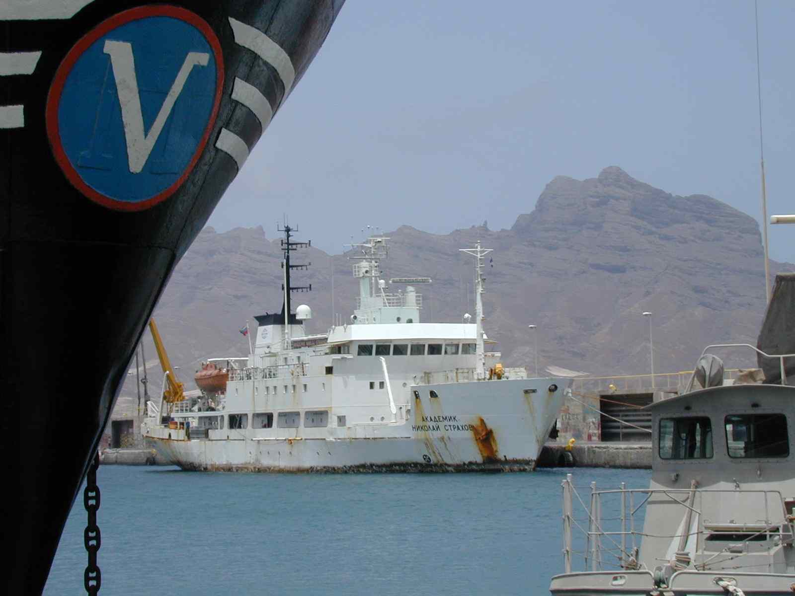
НИС «Академик Николай Страхов» в порту Минделу (Республика Кабо Верде), 2000 год
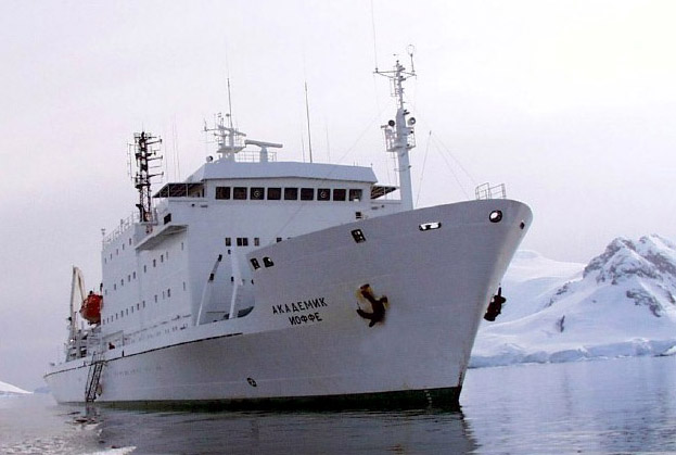
НИС «Академик Иоффе» в Антарктиде
Новые данные составили основу прогноза на открытие сульфидной минерализации
в этом районе [Мазарович и др., 2001]. В 2001 году здесь прошли работы
экспедиции ГИН РАН на НИС «Академик Иоффе» (начальник экспедиции – С.Г.Сколотнев),
которые опирались на вышеупомянутый прогноз, а также на батиметрическую
съемку при помощи многолучевого эхолота SIMRAD EМ-12 на НИС «Академик Николай
Страхов». Они принесли новые данные о наличии сульфидов в прогнозированной
точке, а также в другом сегменте рифта с пониженным фоном сейсмичности
- глубочайшей впадине в пределах рифтовой зоны Срединно-Атлантического
хребта (впадина Маркова - 4975 м).
Все вышесказанное является веским доводом в пользу того, что асейсмичные
области (в смысле отсутствия сильных событий при невозможности регистрировать
слабые вдоль всей оси хребта) срединно-океанических хребтов с небольшой
скоростью спрединга представляют собой районы наиболее благоприятные для
формирования гидротермальных систем и, следовательно, для концентрации
сульфидных минералов. Эти соображения позволяют делать прогноз наиболее
вероятных районов находок сульфидной минерализации в Атлантическом океане.
В основу прогноза легли данные спутниковой альтиметрии [Sandwell,
Smith, 1997, Smith, Sandwell, 1997], положение эпицентров землетрясений
[CNSS.., 1997], а также различные геологические данные.
Положение гидротермальных полей и сульфидной минерализации в Атлантике
В Атлантическом океане к настоящему времени обнаружено несколько
активных и неактивных гидротермальных полей и метановые факелы, которые
открыты между районом 14° с.ш. и Исландией (рис.
1).
Положение гидротермальных полей
Анализ тектонического положения активных гидротермальных полей показывает,
что существует две основных группы. Первая (Рейнбоу, Лаки Страйк, Рейкъянес
и др.) концентрируется на участках Срединно-Атлантического хребта непосредственно
прилегающих к Азорской и Исландским горячим точкам. Для этих частей спрединговой
системы характерно отсутствие трансформных разломов со значительными смещениями
и сглаженная морфология рельефа. Особенности их строения неоднократно рассматривались
в литературе (например – [Альмухамедов и др., 1990]). Вторая группа (Брокен
Спур, ТАГ и др.) находятся в части хребта для которой характерно существование
крупных трансформных разломов (Атлантис, Кейн, Зеленого Мыса), отстоящих
друг от друга на сотни километров, между которыми устанавливается большое
количество разрывов (“discontinuty”). Глубина положения полей изменяется
от сотен метров (хребет Рейкьянес) до 3650 м (активный холм ТАГ). Именно
в областях изгибов рифтовых долин и концентрируются «черные курильщики»).
Как пример можно рассмотреть положение поля Брокен Спур (рис.
2а). Здесь отчетливо видны «подходы» разрывов и искривления рифтовой
долины.
Положение неактивных гидротермальных полей совпадает с зонами активной гидротермальной деятельности, за исключением построек севернее разлома Зеленого Мыса и севернее разлома Кейн. Однако в обоих случаях эти районы также отличаются относительно меньшей сейсмичностью. Глубина положения полей изменяется от 1700 м (Лаки Страйк) до 3900 м (район 24°30’ с.ш.).
Положение сульфидной минерализации
Проявления сульфидной минерализации разного генезиса, а также зоны
интенсивной гидротермальной проработки коренных пород имеют более широкую
географию – от района разлома Атлантис до тройной точки Буве. Глубина станций,
с которых поднимались сульфиды изменяется от 2200 м (гора Ферсмана) до
4800 м (впадина Маркова).
Помимо широко известных данных в отечественной и зарубежной литературе
содержатся сведения, дополняющие базу данных InterRidge о сульфидной минерализации
и дегазации из океанского дна. Эта информация была получена в ходе экспедиций
НИС "Антарес", 9 рейс, драга 46 (1990), НИС "Академик Николай Страхов",
7 рейс, драга 71 (1988 г.), 9 рейс, драга 27, 36, 41 (1989 г.), 18 рейс,
драга 43 (1994 г.), 22 рейс, драга 34 (2000 г.), НИС "Джеймс Джиллис",
7309 рейс, драга 58, 93 (1973 г.), НИС "Пиллсбери", 7003 рейс, драга 25
(1970 г.), НИС "Геолог Ферсман", рейс неизвестен, драга 74, 130, 192, НИС
"Академик Иоффе", 10 рейс, драга 32 (2001 г.), НИС "Геленжик", 96 рейс,
драга 17 (1996 г.), НИС " Академик Курчатов ", 20 рейс, фото газовых пузырей
(1975 г.)
Сульфиды поднимались из разных частей склонов рифтовых долин, с
угловых поднятий (гора Ферсмана), поперечных хребтов (запад активной части
разлома Романш), непосредственно в областях разрывов (разлом Сьерра-Леоне)
(рис.3 А), а также вне современных рифтов (район
о.Буве и хребет Шписс). Практически во всех случаях их нахождение было
связано с зонами тектонизации и интенсивной гидротермальной переработки
вмещающих пород и совпадает с зонами пониженного фона сейсмичности.
Вероятное положение сульфидной минерализации
в структуре южной Атлантики между экватором
и 55° ю.ш.
В Южной Атлантике имеются только единичные находки сульфидов и одно
указание на гидротермальную переработку пород (район 24° ю.ш.) (рис.
4).
Срединно-Атлантический хребет характеризуется субмеридиональным простиранием
и не испытывает крупных изгибов или трансформных смещений. Наложение эпицентров
землетрясений на альтиметрию показало, что здесь, также как и в северной
Атлантике существуют асейсмичные участки, причем некоторые из них по своей
протяженности превышают аналогичные участки в северной части (южнее о.
Вознесения, 52° ю.ш.) (рис. 4). Обращает на себя
внимание, что они могут быть как связанными с зонами разрывов, так и нет.
Исходя из принципов, которые обсуждались в предыдущем разделе, видимо,
целесообразно сосредоточить внимание на первых. Такими перспективными районами
могут быть районы южнее о. Вознесения, который отличается очень сложным
строением, район между разломами Мартин Вас и Хотспер, 20° ю.ш. (рис. 3
Б) и район 45° ю.ш. Два сходных участка имеются и на Африкано-Антарктическом
хребте (см. рис. 4) – районы разлома Шака и Жабару.
Особое место занимают зоны асейсмичности в районе тройной точки
Буве. Как уже говорилось выше, в них также была обнаружена сульфидная минерализация.
Первый район представляет собой хребет Шписс на котором была закартирована
огромная кальдера. Известно, что с крупной кальдерой Осевого вулкана (Axial
Volcano), правда в другой геодинамической обстановке, на хребте Хуан-де-Фука,
связано крупное гидротермальное поле, которое изучается сейчас в рамках
проекта NeMO (New Millenium Observatory) (http://newport.pmel.noaa.gov/nemo_cruise98/project.html).
Второй район расположен непосредственно около о. Буве или, другими словами,
в районе горячей точки Буве.
ОБСУЖДЕНИЕ
Срединно-Атлантический хребет относительно неплохо изучен драгировками,
которые были получены в течение более чем 100 лет. Общее количество полученных
образцов авторам не известно, но мы располагаем данными о 4500 станций.
Судя по этой случайной выборке, хребет изучался в диапазоне глубин от 5000
м до первых десятков метров. Были опробованы все основные морфоструктуры
рифтовых долин и активных частей трансформных разломов. При этом количество
драгировок с сульфидной минерализации составляет малый процент. Так, например,
НИС «Академик Николай Страхов» провел около 850 драгировок из них только
6 содержали сульфиды (0.7 %). Это доказывает, что сульфиды не развиты в
пределах всего хребта в виде сплошного пояса, а локализуются в определенных
узлах.
Важнейшим вопросом для понимания положения сульфидной минерализации
должен быть вопрос о природе асейсмичных участков хребта. Наиболее вероятным
представляется относительно сильный прогрев этих районов, который обеспечивает
пластичность литосферы. Это подтверждают и данные о тепловом потоке [Подгорных,
Хуторской, 1997]. В пределах осевой зоны Срединно-Атлантического хребта
повышенные значения теплового потока (>70 мВт/м2) отмечались именно на
асеймичных участках (например район впадины Маркова, в районе 10 с.ш.,
разлом Св.Петра). Хотя повышенные тепловые потоки отмечаются и на поперечных
хребтах (разлом Вима). Аномальность рассматриваемых районов проявляется
и в рельефе. Здесь существуют сложно построенные узлы, отличительной чертой
которых являются крупные блоки внутри зон разрывов (например гора Леонова
в разломе Сьерра-Леоне, разлом Св.Петра, участок рифта между разломами
Зеленого Мыса и Марафон), которые были хорошо закартированы многолучевыми
эхолотами во время экспедиций НИС «Академик Николай Страхов». Судя по данным
«предсказанной топографии» [Smith, Sandwell, 1997] такие зоны существуют
и в южной части Атлантики (см. рис. 3Б, 4).
Перейдем к корреляции обсуждаемых данных по профилю вдоль Срединно-Атлантического
хребта (рис. 5).
На рисунке обобщена информация о рельефе и силе тяжести в свободном воздухе, сейсмичности, положения сульфидой минерализации, аномалиям Буге и сейсмической томографии. По отношению ко всему, связанному собственно с сульфидной минерализацией, сейсмическая томография, сейсмичность и гравитационные аномалии представляют собой фоновый набор данных, на базе которого производится корреляция. Этот набор характерен непротиворечивой взаимной интерпретацией коррелируемых аномалий и особенностей, выделяемых на профиле, на чем следует остановиться подробнее.
Сейсмическая томография, полученная по данным поперечных волн, в наибольшей степени отражает температурный режим и частичную расплавленность мантии [Becker, Boschi, 2002]. Для анализа была выбрана модель RG5.5 [Zhang, Tanimoto, 1992], представленная для сферических гармоник до 36 порядка при параметризации на блоках 5°х5°, в частности профиль вариации скорости вдоль САХ до глубины 500 км. На этом профиле отчетливо видны три минимума (см. рис. 5 В), соответствующие (с севера на юг) Исландскому, Азорскому и южноатлантическому плюмам. Особенностью базальтового магматизма над этими плюмами [Дмитриев и др., 1999] является повышенная продуктивность, что при низкой скорости спрединга создает отчетливые положительные аномалии рельефа дна вдоль оси хребта, поскольку накопление базальтовых продуктов в этих зонах САХ будет существенно большим, чем в зонах проявления фонового типа магматизма [Dmitriev et al, 2001б]. Эти аномалии рельефа формируют соответствующие аномалии силы тяжести в свободном воздухе (см. рис. 5 А), которые в значительной степени отражают вариацию наиболее контрастной плотностной границы вода/дно (кора). Устранение влияния рельефа из значений аномалии силы тяжести в свободном воздухе по схеме классической аномалии Буге для плотности 2.75 г/см3 оставляет в аномальном поле составляющую, в основном представляющую вариацию границы М, поскольку это следующая наиболее контрастная граница плотностного разреза вблизи поверхности (см. рис. 5 В). Полученная аномалия Буге вследствие работы изостатических механизмов зеркальным образом (по сравнению с аномалиями в свободном воздухе) отражает аномалии рельефа, связанные с интенсивными выплавками базальтов плюмовой ассоциации. Кроме влияния границы М в этой аномалии присутствует влияние и более глубинных (но менее контрастных) плотностных неоднородностей, вклады которых в аномальное поле мы не разделяли. Отметим совпадение главных зон минимумов аномалии Буге с соответствующими минимумами томографического разреза, представленными зонами разуплотненной мантии, но при этом также отметим отчетливо заметное южное смещение центров Азорского и Исландского плюмов приблизительно в 10 дуговых градусов (~1000 км). Существование подобного смещения томографических аномалий от аномалий Буге связано с тем, что вклад глубинных вариаций плотности существенно меньше вклада в аномалию Буге вариации границы М. Это означает, что расположение разуплотненного мантийного вещества плюма смещено относительно массивных базальтовых выплавок, подчеркнутых гравитационными аномалиями. Сказанное не противоречит имеющимся литературным данным о южной миграции Азорского плюма [Dmitriev et al, 2001a; Дмитриев и др., 2001; Cannat et al, 1999].
Перейдем к анализу рис. 5 Б, фоновую основу
которого составляют данные о сейсмичности [CNSS…, 1997]. Корреляция сейсмичности
с другими геофизическими параметрами рис. 5 показывает, что в области проявления
плюмов сейсмические события происходят чаще и с меньшей магнитудой, чем
в области «холодной» мантии в приэкваториальной зоне и отдельных фрагментов
на севере. Подробнее корреляция сейсмичности с геофизическими и петрологическими
параметрами изложена в [Дмитриев и др., 1999]. Сказанное не относится к
пониженному уровню частоты сейсмических событий в Южной Атлантике, который
обусловлен менее плотной системой регистрирующих станций в этой части света.
Отчетливо видно, что распределение сейсмичности вдоль хребта имеет характер
«сгустков» размером около 1.5–2 дуговых градуса, к промежуткам между которыми
тяготеют известные проявления сульфидной минерализации и других явлений
связанных с ней. Рассматривая относительно хорошо изученную Северную Атлантику
необходимо отметить, что проявления сульфидной минерализации тяготеют не
просто к зонам пониженной частоты сильной (для выборок событий более 4
баллов) сейсмичности, а к зонам ассоциированным с плюмовыми явлениями в
верхней мантии.
На наш взгляд наиболее вероятным механизмом, реализующим эту связь,
является то, что наличие плюма, продвигающегося (или просто функционирующего)
вдоль хребта приводит к возникновению дополнительной системы трещиноватости
коры, что облегчает доступ воды, ее циркуляцию и обогащение компонентами,
свойственными гидротермальным растворам. Кроме того, интенсивный базальтовый
магматизм плюмового типа, поставка в зоне плюма необходимых летучих компонент
и повышенный тепловой поток создают дополнительные условия, способствующие
гидротермальной активности. Зоны трещиноватости способствуют также развитию
процессов серпентинизации и связанному с этим выделению метана [Charlou
et al, 1998; Дмитриев, Базылев и др., 1999; Dmitriev et al, 2001в]. Отмечается
также незначительное смещение на юг активных гидротермальных построек от
пассивных, что также может свидетельствовать о миграции плюма и гидротермальных
систем, взаимосвязанных с ним. Это означает, что обнаружение признаков
гидротермальной деятельности, прогнозируемое в зонах отсутствия сильной
сейсмичности, может осуществляться не только в областях современного наличия
мантийных плюмов, но и в других областях, которые расположены вне зоны
САХ и могут содержать гидротермальные палеопостройки.
ВЫВОДЫ
1. Активные и неактивные гидротермальные постройки и сульфидная минерализация.в
пределах осевой зоны САХ не располагаются случайным образом, а локализованы
в пределах зон с повышенной пластичностью, которые отличаются пониженным
фоном сейсмичности (для выборок с магнитудой больше 4).
2. С этими же зонами часто связано появление зон разрывов (“discontinuty”),
которые могут являться дополнительным доказательством разуплотнения (повышенной
пластичности) коры этих частей САХ.
3. Поиск гидротермальных построек и сульфидной минерализации целесообразно
сосредоточить, помимо сказанного выше, в зонах развития плюмов, которые
выявляются по сейсмотомографическим данным как в северной так и южной частях
Атлантического океана.
Литература
Альмухамедов А.И., Богданов Ю.А., Кузьмин М.И., Сборщиков И.М., Хворова
И.В., Сагалевич А.М., Аношин Г.М., Бартенева Л.И., Беляев И.И., Бирюков
С.Г., Кашинмкая И.В., Комаров А.В., Купцов В.М., Лисицина М.А., Лукашина
М.П., Палкина А.М., Пальшин М.А., Подражанский А.Н., Попов Э.А., Попов
В.А., Римский-Корсаков Н.А., Руденко М.В., Трухин В.И., Шрейдно А.А. Рифтовая
зона хребта Рейкьянес: тектоника, магматизм, условия осадконакопления.
М.: Наука, 1990. 236 с.
Геологические исследования в центральной Атлантике (Ред.: В.В. Шарапов,
В.А. Симонов). Новосибирск: Изд-во ИГиГ СОАН СССР. 1991. 192 С.
Дмитриев Л. В., Базылев Б. А., Силантьев С. А., Борисов М. В., Соколов
С. Ю., Буго А. Образование водорода и метана при серпентинизации мантийных
гипербазитов океана и происхождение нефти. // Российский журнал наук о
Земле. 1999. Ноябрь. Т.1. №.6.
Дмитриев Л. В., Соколов С. Ю., Мелсон В. Г., О'Хирн Т. Плюмовая
и спрединговая ассоциации базальтов и их отражение в петрологических и
геофизических параметрах северной части Срединно-Атлантического хребта.
// Российский журнал наук о Земле. 1999 Ноябрь. Т.1. №.6.
Дмитриев Л.В., Соколов С.Ю., Короновский Н.В., Соколов Н.С. Миграция
Азорского суперплюма по данным о корреляции петрологических и геофизических
параметров. // Геология и геофизика срединно-океанических хребтов. Российское
отделение InterRidge. (23-25 мая 2001 г.). с. 11.
Дубинин Е.П., Ушаков С.А. Океанический рифтогенез. М. ГЕОС. 2001.
293 с.
Лукашин В.Н., Лисицын А.П., Иванов Г.В., Кравцов В.А., Русаков В.Ю.
Исследование гидротермальных плюмов над рифтовой зоной Срединно-Атлантического
хребта в районе 29° с.ш.//Океанология. 1997. Т.37. № 5. С.770-779.
Мазарович А.О., Соколов С.Ю. Тектоническое положение гидротермальных
полей на Срединно-Атлантическом хребте.//Литология и полезные ископаемые
1998. № 4. С. 436-439
Мазарович А.О. Геологическое строение Центральной Атлантики: разломы,
вулканические сооружения и деформации океанского дна. М.: Научный Мир.
2000. 176 с.
Мазарович А.О., В.А.Симонов, А.А.Пейве, С.В. Ковязин, Г.А. Третьяков,
Ю.Н.Разницин, Г.Н.Савельева, С.Г.Сколотнев, С.Ю.Соколов, Н.Н.Турко. Гидротермальная
минерализация разлома Сьерра-Леоне (Центральная Атлантика) // Литология
и полезные ископаемые. 2001. № 5. С. 1 – 8
Отчет о 20-м рейсе научно-исследовательского судна "Академик Курчатов"
(геолого-геофизическая экспедиция в Атлантический океан) 29.01-29.05.1975
года. ИОАН 1975.
Погребицкий Ю.Е., Горячев Ю.В., Осипов В.А., Трухалев А.И. Сроение
океаническрй литосферы по результатам исследований на Анголо-Бразильском
геотраверсе.// Советская геология.1990. №12. С.8-22.
Подгорных Л.В., Хуторской М.Д. Карта планетарного теплового потока
масштаба 1:30000000. М.–С-Пб.: ВНИИОкеангеология, 1997.
Разницин Ю.Н., Сколотнев С.Г., Турко Н.Н., Мазарович А.О., Пейве
А.А., Штеренберг Л.Е. Зона сочленения разлома Марафон с рифтовой долиной:
структура, вещественный состав пород, сульфидная минерализация (Центральная
Атлантика). // Докл. АН СССР. 1991. Т. 320. N 4. С. 952-956.
Трухалев А.И., Воробьев П.В., Степанова Т.В., Степанов М.А. Некоторые
черты тектоники и магматизма рифтовой зоны Срединно-Атлантического хребта
в районе 24-25° с.ш. // Гидротермальные системы и осадочные формации срединно-океанических
хребтов Атлантики. М.: Наука, 1993. С. 72-112.
Becker T. W., Boschi L. A comparison of tomographic and geodynamic
mantle models. // Geochemistry, Geophysics, Geosystems. G3. V.3. January
10, 2002. Paper number 2001GC000168.
Bonatti E., Guerstein-Honnorez B.M., Honnorez J. and Stern G. Hydrothermal
pyrite concretions from the Romanche trench (Equatorial Atlantic): metallogenesis
in oceanic fracture zones // Earth and Planet Sci. Lett. 1976. V. 32, ?
1. P. 21-37.
Cannat M., Briais A., Deplus C., Escarti J., Georgen J., Lin J.,
Mercouriev S., Meyzen C., Muller M., Pouliquen G., Rabain A., da Silva
P. Mid-Atlantic Ridge–Azores hotspot interactions: along-axis migration
of a hotspot-derived event of enhanced magmatism 10 to 4 Ma ago.// Earth
Planet. Sci. Lett. 1999, 173, 257-269
Carrara G., Bortoluzzi G., Zittelini N., Bonatti E., Brunelli D.,
Cipriani A., Fabretti P., Gasperini L., Ligi M., Peniteni D., Sciuto P.F.,
Mazarovich A., Peyve A., Turko N., Skolotnev S., Gilod D. The Bouvet Triple
Junction Region (South Atlantic): a report on two geological expeditions.
//Giornale di Geologia. Ser. 3. 1997. V. 5911. # 2. P. 19 - 33.
Charlou J.L., Fouquet Y.,Bougault H., Donval J.P., Etoubleau J.,
Jean-Baptiste P., Dapoigny A., Appriou P., Rona P. Intense CH4 plumes generated
by serpentinization of ultramafic rocks at the intersection of the 15o20'
N fracture zone and the Mid-Atlantic Ridge. // Geochim. Et Cosmochim.
Acta, v. 62, #13, 1998, 2323-2333.
CNSS Earthquake Composite Catalog. June 1997 (http://quake.geo.berkeley.edu/cnss/)
Dmitriev L.V., Koronovsky N.V., Sokolov S.Yu., Sokolov N.S.
Tectonic-magmatic history of the North Atlantic lithosphere formation by
the isochrone gravity profiling. // European Geophysical Society. 26th
General Assembly. 2001. Geoph. Res. Abs. 3. P. 818.
Dmitriev L.V., Silantiev S.A., Sokolov S.Yu. Plume and spreading
TOR assemblages, spreading rate, ridge segmentation and geophysical fields
distribution. // European Geophysical Society. 26th General Assembly. 2001.
Geoph. Res. Abs. 3. P. 819.
Dmitriev L.V., Bazylev B.A., Borisov M.V., Bougault H., Silantiev
S.A., Sokolov S.Yu. The serpentinization of the oceanic mantle peridotites
and the Earth fluid regime. // European Geophysical Society. 26th General
Assembly. 2001. Geoph. Res. Abs. 3. P. 795.
Hannington M. Hydrothermal Vent Database. InterRidge Databases.
2001.
(http://triton.ori.u-tokyo.ac.jp/~intridge/data1.html)
Peyve A., Bonatti E., Brunelli D., Chilikov A., Cipriani A., Dobrolubova
K., Efimov V., Erofeev S., Ferrante V., Gasperini L., Hekinian R., Ligi
M., Maurizio G., Mazarovich A., Perfiliev A., Raznitsin Y., Savelieva G.,
Sichler B., Simonov V., Skolotnev S., Sokolov S., Turko N. New data on
some major MAR structures: preliminary results of R/V Akademik Nikolaj
Strakhov 22 cruise // InterRidge News. V. 9 (2). 2000. P. 28.
Sandwell D.T., Smith W.H.F. Marine Gravity Anomaly from Geosat and
ERS-1 Satellite Altymetry // J. Geophys. Res. 1997. V. 102. # B5. P.10039-10054.
Smith W. H. F., Sandwell D. T. Global Seafloor Topography from Satellite
Altimetry and Ship Depth Soundings // Science. 1997. Sept. 26. V. 277 (5334).
Zhang Y.S., Tanimoto T. Ridges, hotspots and their interaction,
as observed in seismic velosity maps. // 1992, NATURE, 355, 45-49.
Litbology and Mineral Resources, Vol. 33, No. 4, 1998, pp. 391-394. Translated from Litologiya i Poleznye iskopaemye, No. 4, 1998, pp. 436-439. Original Russian Text Copyright © 1998 by Mazarovich&Sokolov.
A. O. Mazarovich and S. Yu. Sokolov
Received February 11, 1998
Abstract
The work at compiling a digital tectonic map of the Central Atlantic is carried out in the Laboratory of geomorphology and tectonics of the oceanic floor, Institute of Geology, RAS. This work is accompanied by creating the database and analyzing widely diverse materials. In the course of these investigations, the authors have accumulated observations that might be of interest to the specialists in the field of oceanic hydrothermal systems.
High-temperature hydrothermal sources were discovered in the late 1970s. At present, more than 100 hydrothermal active and relic fields of the World Ocean have been studied to a variable extent of detail (Rona and Scott, 1993).
Regional investigations (Rona, 1986; Rona and Scott, 1993; etc.) have shown that the majority of hydrothermal ore occurrences are situated within the boundaries of neovolcanic rift zones on the Mid-Atlantic Ridge (TAG, Snake Pit, and Broken Spur) and gravitate to the volcanic arches of these zones. It has been noticed that active hydrothermal sources are most frequently confined to the tectonic disturbance zones. The situation is known when the active hydrothermal field (e.g., Logachev field) is located on the surface of marginal bench of the rift valley, this bench being composed of serpentinized ultrbasic rocks (Bogdanov et al., 1995). This situation does not fit well into the existing scheme of hydrothermal system circulation on spreading ridges.
When the map of magmatism of the Central Atlantic was compiled, the idea arose to reflect on it the position of hydrothermal fields as well. Upon their plotting on the map of gravitational anomalies compiled from satellite data (Sandwell and Smith, 1997), we compared the picture obtained with the position of earthquake epicenters (1937-1997). Information on the earthquakes was obtained via the Internet from the catalog of the National Earthquake Information Center (USA). This comparison has revealed the following.
The Logachev Field, recently discovered in the 14°15' N region (Bogdanov, 1995), is situated in the segment of the Mid-Atlantic Ridge between the Cape Verde and Marathon fractures. Analysis of the altimetric map (Fig. 1a), combined with the earthquake epicenters, has showed that the aseismic region is located precisely in this area. The zone of extensive gravitational anomalies registered as a trench in relief is also located in this area. The anomalies are traced to many hundreds of km east and west of the ridge axis. Note that the three among five well known deepfocus earthquakes in the axial part of the Atlantic Ocean with the epicenter depths of 60, 60, and 51 km and magnitudes 6,7.3, and 4.7, respectively, are connected with the same lineament.

Fig. 1a. Logachev
hydrothermal field and earthquackes epicenters position
black dots - epicenters; stars
- hydrothermal fields; rings -aseismic gaps

Fig. 1b. Hydrothermal
fields and earthquackes epicenters position on Kane FZ region
black dots - epicenters; stars
- hydrothermal fields; rings -aseismic gaps
The TAG, Snake Pit, and Broken Spur hydrothermal fields (Fig. 1b) are also situated either in aseismic zones or near them. The extensive bottom depressions (fractures) are also located near them. Deep-focus earthquakes have not been established in the Kane Fracture Zone. Within the TAG field, hydrothermal edifices were formed either on the surface of intensely crushed basement or within the talus composed of volcanite fragments (Lisitsyn et al., 1990). The well-known hydrothermal plumes (Lukashin etal., 1997) fall into the aseismic zone as well.
The results obtained indicate that hydrothermal fields gravitate to the relatively stable parts of rift zones, which are obviously most favorable for the stable circulation of hydrotherms under the conditions of spreading at low velocities. Such regions are situated in the discontinuity areas.
The general scheme of formation of hydrothermal solutions is well known and reduced to the following. Within the boundaries of rifts, oceanic water penetrates into the crust via the system of open cracks (gjars) and is heated to near-critical temperatures (over 400°C) due to its interaction with rocks of the oceanic crust and magma chambers. Thereafter, ore-forming hydrothermal solutions enriched in various elements penetrate to the surface and are discharged as "black smokers" and other polymetallic ore occurrences (Lisitsyn et al., 1990; Rona, 1986; Karson and Rona, 1990; etc.). The tectonic position of hydrothermal fields, established by the authors, can refine the existing models.
Open cracks within the rift zone are oriented sub-parallel to its strike. It would be reasonable to suggest that the solutions will migrate not across the rift, as is commonly believed, but in the directions with the best conditions of permeability, i.e., along the rift strike (similar to the fractured reservoirs in oil traps). It is possible that this motion is directed toward the most uplifted parts of the rift valley. In this case, the hydrothermal discharge zones must be situated in the most stable areas, where the favorable conditions for the long-term (up to tens of thousands of years) stable circulation of hydrothermal solutions exist. Such ascending "jets" are situated precisely within the regions with zero or reduced seismicity revealed by the authors. The discontinuities seem to represent the regions with an increased amount of breccias, in other words, with the increased open porosity and permeability (Fig. 2).

CONCLUSION
The major circulation of oceanic water and its transformation into ore-forming solutions proceeds along the strike of rift zones with the subsequent discharge in relatively stable areas.
Analysis of the arrangement of earthquake epicenters on the Mid-Atlantic Ridge between 30°N and 15°S shows that there are a number of regions within the specified boundaries (south of the Ascension Fracture Zone and others) with reduced seismicity or alltogether without it (Fig. 3), which coincide with the discontinuity areas. We assume these are the most promising areas for the discovery of hydrothermal fields.


Fig. 3. GEBCO (top)
and altimetry maps (bottom) on MAR (11°- 6° S, 20°- 5° W)
black dots - epicenters; ellips
-aseismic gaps with hydrothermal field
REFERENCES
Bogdanov, Yu.A., Sagalevich, A.M., Ashadze, A.M., Chernyaev, E.S., Gurvich, E.G., Lukashin, V.N., Ivanov, G.V., and Peresypkin, V.I., Hydrothermal Field at 14°45'N of the Mid-Atlantic Ridge // Dokl. Akad. Nauk. 1995. V. 343. no. 3. pp. 353-357 (in Russian).
Litbology and Mineral Resources, Vol. 36, No. 5, 2001, pp. 460-466.
Translated from Litologiya i Poleznye iskopaemye. No. 5. 2001, pp. 526-533.
Original Russian Text Copyright © 2001 by Mazarovich, Smonov, Peive, Kovyazin,
Tret'yakov, Raznitsin, Siivel'eva, Skolotnev, Sokolov, Turko.
Hydrothermal Mineralization in the Sierra Leone Fracture Zone (Central Atlantic Ocean)
A. O. Mazarovich, V. A. Simonov2, A. A. Peive, S. V. Kovyazin2, G. A. Tret'yakov2, Yu. N. Raznitsin, G. N. Savel'eva, S. G. Skolotnev, S. Yu. Sokolov, and N. N. Turko
Geological Institute of the Russian Academy of Sciences (GIN), Pyzhevsky per. 7, Moscow, 1090] 7 Russia
The analysis of data on the location of hydrothermal fields, seismicity,
and satellite altimetry evidences that in mid-ocean ridges with low spreading
velocity hydrothermal fields tend to be grouped in areas with generally
low seismic activity and at intersections of discontinuities and rift zones.
Based on this assumption, the Sierra Leone Fracture Zone was studied in
2000 during cruise 22 of the R/V Akademik Nikolaj Stra-khov. The study
of gabbrodolerite and dolerite showed that sulfide ore minerals in them
were formed both by hydrothermal and magmatic processes. The analysis of
melt inclusions demonstrated that magmatic complexes formed from a high-temperature
(1210-1255°C) low-potassium melt of the N-MORB type. Investigations of
fluid inclusions revealed that gabbro and dolerite formed under the influence
of an active hydrothermal system at a temperature of 205-226°C. Thus, the
Sierra Leone Fracture Zone is considered to be perspective for the discovery
of a new hydrothermal field.

Fig. 1. Distribution of earthquake epicenters (CNSS..., 1977) in Atlantic Ocean equatorial part.
The map is based on satellite altimetry (Sandwell and Smith, 1997). Arrows indicate the areas with lowered seismicity. Latitudes and longitudes are given in degrees up to the decimal place.
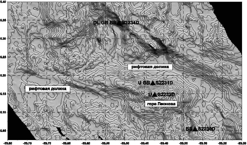
Fig. 2. Seafloor topography
at the intersection of the rift valley and Sierra Leone Fracture Zone
(100 m contour interval).
Triangles are locations of dredging stations.
Stations are numbers given to the right; rocks types, to the left. (BS)
Basalts, (U) ultramafic rocks, (GB) gabbro, (DL) dolerites.
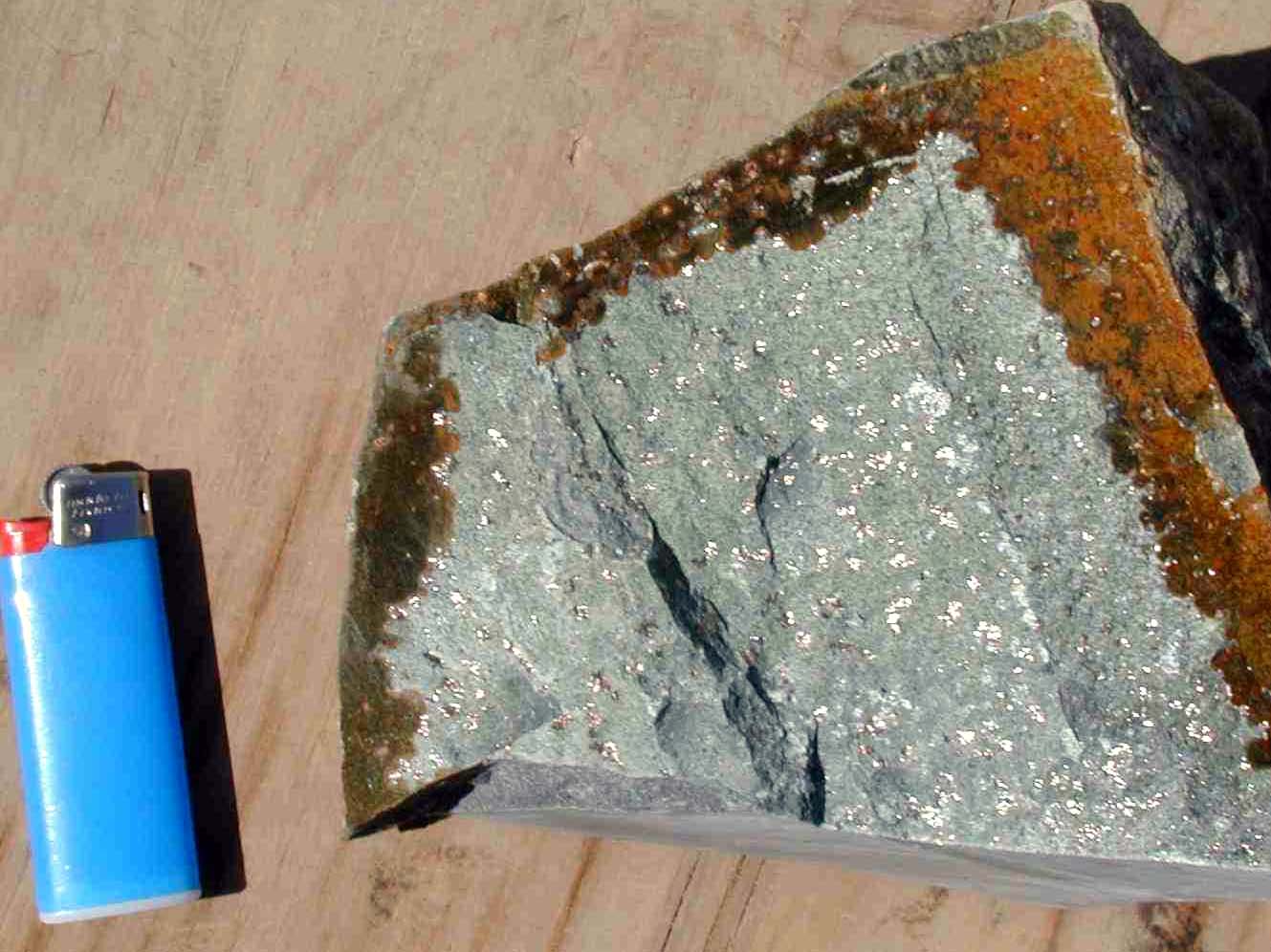
Dolerite with sulfides.
Foto - P.Morozzi (IGM CNR, Bolognha, Italy)
STUDY METHODS. Compositions of sulfides, melt inclusions, and inclusions-hosting minerals were determined using a Camebax-Micro X-Ray analyzer. The melt inclusions were studied in the high-temperature thermochamber with an inert medium (Sobolev and Slutskii, 1984). Experiments with the inclusions were executed taking into consideration the recommendations proposed in (Magmatogenfiaya kristalliz.atsiya..., 1975; Sobolev and Danyushevsky, 1994), as well as on the basis of our own experience (Simonov, 1993). Fluid inclusions were studied with the help of thermometric and cryo-metric methods (Ermakov and Dolgov, 1979; Roedder, 1984) in the medium-temperature chamber and cryo-chamber with an original design (Simonov, 1993). Data on fluid inclusions were processed on a computer using the PETROLOG Program (Danyushevsky, 1998). Thus, we obtained additional information on parameters of the basaltic magma systems.
The analytical study was conducted at the United Institute of Geology, Geophysics, and Mineralogy, Novosibirsk.
PETROGRAPHIC AND MINERALOGICAL FEATURES OF ROCKS. Hydrothermal rocks at stations S2231 and S2232 are mainly represented by carbonate veins in ultramafic rocks often containing vugs and druses of small arago-nite crystals. Breccia of serpentinite clasts is of particular interest. It is cemented by carbonate material with overgrowths of druses of elongated small aragonite crystals (up to 5 mm). At Station S2234, the influence of hydrothermal systems on rocks is expressed in the replacement of clinopyroxene by amphiboles (predominantly actinolite) and wide development of sulfides.
The analysis of melt inclusions reveald that magmatic rock associations from Station S2234 formed from low-potassium (probably H2O-poor) primitive melts of the N-MORB type. Thus, endogenic fluid components of these melts hardly could strongly effect the composition of rock-altering hydrothermal solutions.
Danyushevsky, L.V., The Effect of Small Amount of Н2О on Fractionation of Mid-Ocean Ridge Magmas, Abstr. AGU Spring Meeting, EOS 79, 1998, no. 17, suppl., p. 375.
Ekvatorial'nyi segment Sredinno-Atlanticheskogo khrebta. Prilozhenie k nionografii "Ekvatorial'nyi segment Sredinno-Atlanticheskogo khrebta" (Equatorial Segment of the Mid-Atlantic Ridge: Appendix to the Monograph Equatorial Segment of Mid-Ocean Ridge) MOC UNESCO, Vernadsky Inst. Geokhim. Analit. Khim, Ross. Akad. Nauk: ATKAR PKO Kartografiya, 1997. (in Russian)
Russian Journal of Earth Sciences
Hydrothermal fields in the Mid-Atlantic Ridge: Setting and prospects of further discoveries
A. O. Mazarovich and S. Yu. Sokolov
Abstract
Analyzed is the setting of active and inactive hydrothermal fields and sulfide occurrences on the Mid-Atlantic Ridge between 65°N and 65°S. Multifaceted interpretation of the data has enabled a prediction of how sulfide mineralization is distributed in the Atlantic Ocean.
Introduction
Analyzing the InterRidge database (Hannington, 2001) shows that,
by now, 97 active hydrothermal fields have been discovered in all the earth’s
oceans, including seas. Of the entire population, 15 occurrences fall in
the Atlantic basin, 72 in the Pacific, and the rest, in the Indian and
Arctic oceans. This study is focused on the Atlantic Ocean alone, between
Iceland on the north and the Bouvet triple junction region on the south.
Several years ago, Mazarovich and Sokolov (1998) noted that on the
Mid-Atlantic Ridge (MAR), hydrothermal fields gravitate to rift zones with
low to zero seismicity (for samples of M 4+ events). In addition, these
regions have been shown to contain discontinuities. Our analysis has covered
the span between ca. 14°N and 30°N. Based on these two criteria, hydrothermal
mineral occurrences may be expected to exist south of 7°N in the Atlantic
Ocean.
There, in the summer of 2000, cruise 22 of the R/V Akademik Nikolai
Strakhov (GIN RAS) was conducted (Peyve et al., 2000), resulting
in the detection of rocks that show hydrothermal alterations and sulfide
mineralization.

R/V Akademik Nikolai Strakhov in Mindelo (Cabo Verde), 2000

R/V Akademik Ioffe in Antarktic
The new data have provided the basis for predicting sulfide mineralization
for this area (Mazarovich et al., 2001). Based on the prediction just mentioned
and on the results of the SIMRAD EМ-12 multibeam echo sounder bathymetric
survey performed by the R/V Akademik Nikolai Strakhov, this area was re-explored
in 2001 by a GIN RAS team headed by S.G. Skolotnev on board the R/V Akademik
Ioffe. These studies have yielded further evidence for the presence of
sulfides at the predicted locality, as well as in another low seismicity
rift segment, the Markov Hole, which is the deepest (4975 m BSL) basin
in the MAR rift zone.
The above is weighty evidence that aseismic areas (i.e., those lacking
large events and continuous record of small events along the entire length
of the ridge) of slow spreading mid-ocean ridges are most favorable for
hydrothermal systems to form in, and, hence, for sulfide mineralization.
These considerations afford a prediction of localities that hold the greatest
potential for sulfide mineralization in the Atlantic Ocean as well.
Our prediction draws on satellite altimetry data (Sandwell and Smith,
1997; Smith and Sandwell, 1997), earthquake epicenter distribution (CNSS..,
1997), and a variety of geological data.
Hydrothermal fields and sulfide mineralization: Structural setting in the Atlantic
To date, several active and inactive hydrothermal fields and methane plumes have been detected in the Atlantic Ocean between 14°N and Iceland (Fig. 1).
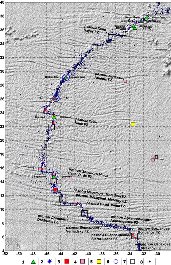
Fig. 1. Location of
active and inactive hydrothermal fields and
sulfide mineralization in the northern part
of the Mid-Atlantic Ridge.
Hereinafter, latitudes and longitudes are given
in degrees (to the first decimal place). Topographic base, from satellite
altimetry data (Smith and Sandwell, 1997). Earthquake epicenters, from
CNSS Earthquake Composite Catalog. 1–2 hydrothermal fields: 1 – active
(with proper names) and 2 – inactive; 3 – sulfide mineralization; 4 – hydrothermal
alteration; 5 – metalliferous sediments; 6 – methane plume; 7 – area with
potential for sulfide mineralization and/or active hydrothermal fields;
8 – earthquake epicenter.
Location of hydrothermal fields
Analyzing the tectonic setting of active hydrothermal fields discerns two principal groups. Group one (Rainbow, Lucky Strike, Reykjanes, etc.) cluster at those segments of the Mid-Atlantic Ridge immediately adjacent to the Azores and Iceland hot spots. These portions of the spreading system are marked by the absence of fracture zones (FZs) with considerable offsets and by smooth topographic relief. Their structural characteristics have been repeatedly discussed in publications (e.g., Almukhamedov et al., 1990)). Group two (Broken Spur, TAG, etc.) are found in that segment of the ridge with major FZs (Atlantis, Kane, Cape Verde) hundreds of kilometers apart and with numerous discontinuities in-between. Water depth above the fields ranges from hundreds of meters (as on the Reykjanes Ridge) to 3650 m (as on the TAG active mound). It is at the bends of rift valleys that black smokers cluster. This can be exemplified by the Broken Spur field (Fig. 2A). Here, clearly visible are rift valley bends and fractures approaching the valley.
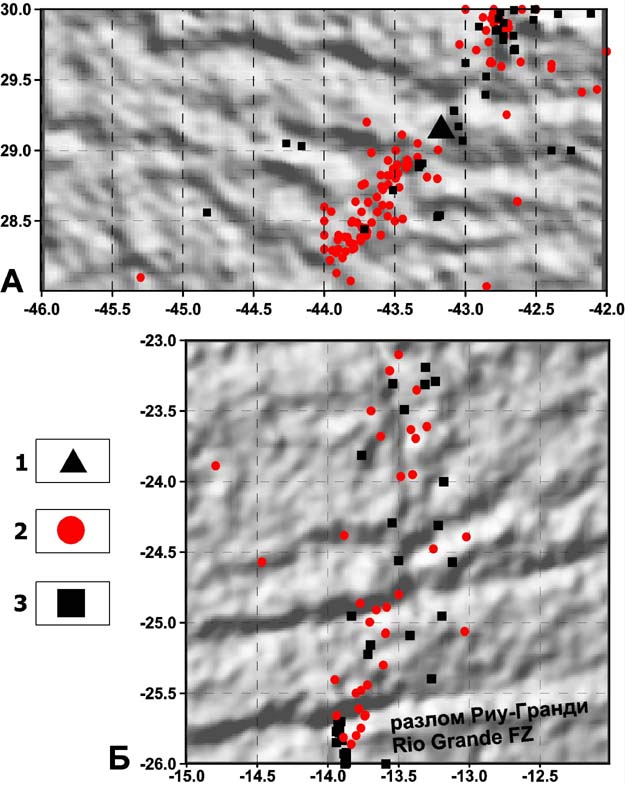
Fig. 2. Relationship of discontinuities and aseismic segments of the Mid-Atlantic Ridge.
А – location of the Broken Spur field. B –
study area in the South Atlantic. Earthquake epicenters, from (CNSS…, 1997).
Cartographic base, from predicted topography
(Smith and Sandwell, 1997). 1 – Broken Spur active hydrothermal field,
2 – earthquake epicenter, 3 – dredge station.
The location of inactive hydrothermal fields coincides with zones of present-day hydrothermal activity, except for the edifices north of Cape Verde FZ and north of Kane FZ. In both cases, however, these are regions that are distinguished by relatively low seismicity. Water depth above the fields ranges from 1700 m (Lucky Strike) to 3900 m (at 24°30'N).
Setting of sulfide mineralization
Sulfide mineralizations of various origins and bedrock zones showing
strong hydrothermal imprints have a wider geographic spread, from the Atlantis
FZ region to the Bouvet triple junction. The stations that yielded sulfides
lie in water depth between 2200 m (Fersman Smt.) and 4800 m (Markov Hole).
Alongside data of common knowledge, Russian and Western publications
offer evidence contributing to the InterRidge database on sulfide mineralization
and seafloor degassing. This information was acquired by the R/V Antares
(cruise 9, dredge 46; 1990), the R/V Akademik Nikolai Strakhov (cruise
7, dredge 71, 1988; cruise 9, dredges 27, 36, 41, 1989; cruise 18,
dredge 43, 1994; cruise 22, dredge 34, 2000), the R/V James Gillis (cruise
7309, dredges 58, 93, 1973), the R/V Pillsbury (cruise 7003, dredge 25,
1970), the R/V Geolog Fersman (cruise not specified, dredges 74, 130, 192),
the R/V Akademik Ioffe (cruise 10, dredge 32, 2001), the R/V Gelenzhik
(cruise 96, dredge 17, 1996), and the R/V Akademik Kurchatov (cruise 20,
the photograph of gas bubbles, 1975).
Sulfides were recovered from various parts of rift valley slopes,
from corner highs (Fersman Smt.), transverse ridges (on the west of the
active segment of the Romanche FZ), directly from the FZs (Sierra Leone
FZ) (Fig. 3A), and outside present-day rifts
(the Bouvet triple junction region and Spiess Ridge). Almost everywhere,
sulfide occurrences were found to be associated with tectonization and
strong hydrothermal imprints in wallrock and to coincide with low seismicity
zones.
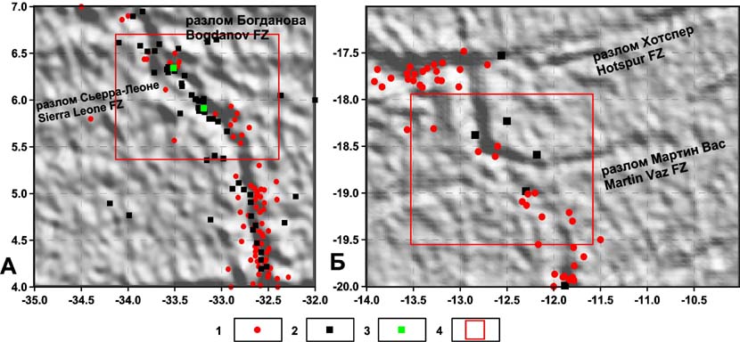
Fig. 3. Location of
sulfide mineralization with respect to aseismic segments of the Mid-Atlantic
Ridge
(Sierra Leone FZ region) (A) and a structurally
similar portion of the South Atlantic (B).
Earthquake epicenters, from (CNSS…, 1997).
Cartographic base, from predicted topography (Smith and Sandwell, 1997).
1 – earthquake epicenter, 2 – dredge station,
3 – dredge station with sulfide mineralization; 4 – structurally similar
areas.
Likely structural setting of sulfide mineralization in the South Atlantic between the equator and 55°S
In the South Atlantic, only sporadic sulfide occurrences and a unique indication of hydrothermally altered rocks (at 24°S) have been reported (Fig. 4). The Mid-Atlantic Ridge trends roughly NS without major bends or transform offsets. Overlaying earthquake epicenters on altimetry data shows that here, just as in the North Atlantic, aseismic tracts exist, some of them being larger than those in the North Atlantic (south of Ascension I., 52°S) (Fig. 4).
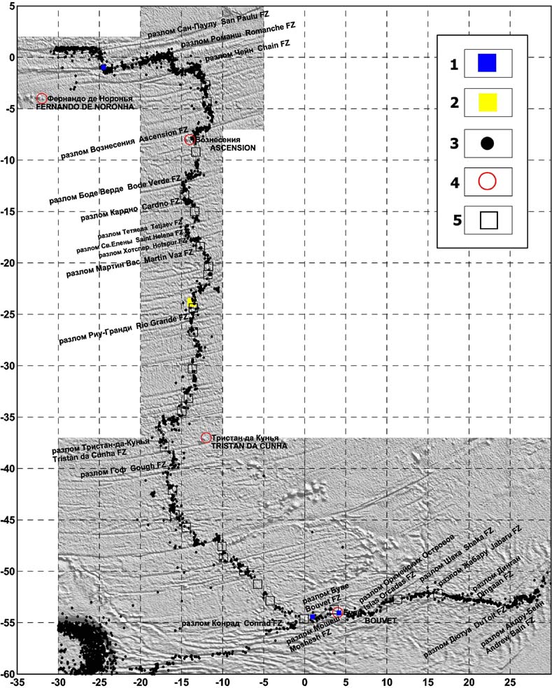
Fig. 4. Map showing predicted sulfide occurrences in the southern part of the Mid-Atlantic Ridge.
Topographic base, from satellite altimetry
data (Sandwell and Smith, 1997). Earthquake epicenters, from CNSS Earthquake
Composite Catalog.
1 – sulfide mineralization, 2 – hydrothermal
alteration, 3 – earthquake epicenter, 4 – hot spot, 5 – area with potential
for sulfide mineralization and/or active hydrothermal fields.
Noteworthy is that they can be either related or unrelated to FZs.
In view of the considerations discussed in the previous section, it is
probably worthwhile to focus on the former. Promising areas like this could
be found south of Ascension I. (which is remarkably complex in architecture),
between the Martin Vaz and Hotspur FZs, 20°S (Fig. 3B), and at 45°S. Two
similar localities exist on the Southwest Indian Ridge (Fig.
4), in the regions of the Shaka and Jabaru FZs.
Of special interest are aseismic zones in the Bouvet triple junction
region. As mentioned above, these zones have also yielded sulfide mineralization.
One locality is the Spiess Ridge, on which a vast caldera has been mapped.
The large Axial Volcano caldera, albeit occurring in a different geodynamic
setting (on the Juan de Fuca Ridge), is known to be associated with a major
hydrothermal field, currently being studied under the NeMO (New Millennium
Observatory) Project (http://newport.pmel.noaa.gov/nemo_cruise98/project.html).
Another locality is situated directly near Bouvet Island — in other words,
in the vicinity of the Bouvet triple junction hot spot.
Discussion
Over a timespan of more than 100 years, the Mid-Atlantic Ridge has
been dredged relatively thoroughly. We do not know the total number of
samples obtained, yet the number of stations from which we have data is
4500. Judging from this random sample, the ridge has been studied in a
depth range from 5000 m to a few tens of meters. Sampling involved all
the principal morphostructures of rift valleys and active segments of the
FZs, the percentage of dredge hauls with sulfide mineralization being very
low. Thus, of the ca. 850 dredge hauls performed by the R/V Akademik Nikolai
Strakhov, only six (0.7%) brought sulfides. This implies that sulfides
are not developed in a continuous belt along the entire length of the ridge,
but are constrained to within certain nodes.
The nature of aseismic segments of the ridge appears to be critical
to unraveling the setting of sulfide mineralization. Most likely, these
segments are zones of relatively high heat flow, which is responsible for
lithospheric ductility. This is further supported by heat flow data (Podgornykh
and Khutorskoy, 1997). It is from aseismic zones of the MAR axial zone
(as, e.g., in the Markov Hole region, at 10°N, and at St. Peter FZ) that
elevated heat flow values (>70 mW/m2) have been recorded. Elevated heat
flow values, however, have been documented on transverse ridges (Vema FZ)
as well. The anomalous nature of these regions is also expressed topographically.
Here, rather complexly built nodes exist, whose distinctive feature is
large blocks sitting inside fracture zones (e.g., Georgy Leonov Smt. in
Sierra Leone FZ; St. Peter FZ; the rift segment between Cape Verde and
Marathon FZs), and which were mapped reliably enough using multibeam echo
sounders during the R/V Akademik Nikolai Strakhov cruises. Judging from
the “predicted topography” data (Smith and Sandwell, 1997), such zones
exist in the South Atlantic as well (Figs. 3B,
4).
Let us now discuss the correlation of the data along a profile drawn
along the Mid-Atlantic Ridge (Fig. 5). This plot
shows generalized information on (i) topographic relief and the free air
gravity field, (ii) seismicity, (iii) distribution of sulfide mineralization,
(iv) Bouguer anomalies, and (v) seismic tomography. With respect to everything
pertaining to sulfide mineralization proper, seismic tomography, seismicity,
and gravity anomalies provide a background data set, based on which correlation
is performed. This data set enables an internally consistent interpretation
of correlative anomalies and those features discernible on the profile.
This is detailed below.
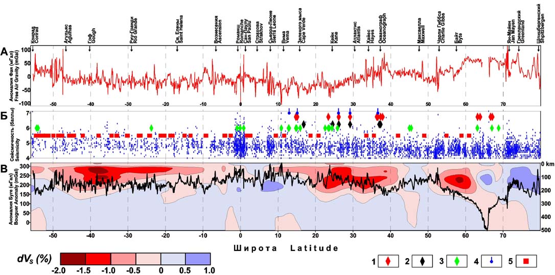
Fig. 5. Correlation
of geophysical fields, seismicity, and hydrothermal occurrences
along the Mid-Atlantic Ridge:
(A) Free air gravity anomaly from satellite
altimetry data (Sandwell and Smith, 1997) and fracture zones intersecting
the MAR;
(B) Seismicity along the MAR (http://quake.geo.berkeley.edu/cnss/),
hydrothermal occurrences, and predicted hydrothermal features: 1
– active hydrothermal occurrence, 2 – inactive hydrothermal occurrence,
3 – sulfide mineralization, 4 – methane plume, 5 – area with potential
for sulfide mineralization and hydrothermal activity. (C) S-wave velocity
section based on the RG5.5 seismic tomography model (Zhang and Tanimoto,
1992) and the classic Bouguer anomaly.
The seismic tomography pattern obtained from S-wave data best reflects
the temperature regime and partially molten state of the mantle (Becker
and Boschi, 2002). Our analysis draws on the RG5.5 model (Zhang and Tanimoto,
1992) for spherical harmonics up to the 36th order parametrized on 5° x
5° blocks, in particular, a velocity variation profile along the MAR to
a depth of 500 km. This profile shows clearly three minima (Fig.
5C), corresponding (from north to south) to the Iceland, Azores, and
South Atlantic plumes. Above these plumes, basaltic magmatism is especially
massive (Dmitriev et al., 1999b). In combination with slow spreading, this
gives rise to distinct positive anomalies of seafloor topography along
the ridge axis, because in these MAR zones basaltic products accumulate
appreciably more vigorously than in zones of “background type” magmatism
(Dmitriev et al, 2001c). These topographic anomalies induce free air gravity
anomalies (Fig. 5A), largely reflecting variations
of the most contrasting density discontinuity, the water/seafloor (crust)
boundary. Following the classic (2.75 g/cm3 density) Bouguer anomaly scheme,
removal of the influence of topography from free air gravity anomalies
leaves an anomalous field that is chiefly induced by variations of the
Moho, because this is the next most contrasting boundary in the density
section near the surface (Fig. 5C). The Bouguer
anomaly thus obtained, due to isostatic mechanisms at work, is a mirror
image (with respect to free air anomalies) of the topographic anomalies
induced by the massive basaltic melts of the plume assemblage. In addition
to the Moho influence, this anomaly includes the influence of deeper seated
(but less contrasting) density inhomogeneities, whose contributions to
the anomalous field we have not separated. On the tomography section, note
the match of the principal Bouguer lows and their correlative minima, represented
by zones of low density mantle, as well as the marked (ca. 10 arc degrees,
or ~1000 km) southward displacement of the Azores and Iceland plumes. Tomographic
anomalies are displaced in this manner from Bouguer anomalies because the
contribution from deep seated density variations is considerably smaller
than that from the Moho. This implies that the region of low density mantle
material of the plume is displaced from the relatively massive basaltic
melts, marked by gravity anomalies. The above is not at variance with the
published data on the southward migration of the Azores plume (Dmitriev
et al, 2001b, 2001d; Cannat et al, 1999).
Let us now analyze Fig. 5B, which draws
on seismic data (CNSS…, 1997). On Fig. 5, correlation
of seismicity with the other geophysical parameters shows that in plume
regions, seismic events are more frequent and have lower magnitudes than
those in the “cool” mantle region near the equator and in certain fragments
to the north. The correlation of seismicity to geophysical and petrologic
parameters is detailed in (Dmitriev et al., 1999b). The above does not
apply to the reduced frequency of seismic events in the South Atlantic,
which is an artifact of the sparser network of recording stations in this
part of the world. It is readily apparent that seismicity distribution
along the ridge shows “clusters” ca. 1.5–2 arc degrees across, with the
documented sulfide occurrences and other related phenomena gravitating
to the spaces between the “clusters.” In discussing the relatively well-understood
North Atlantic, it is worth notice that sulfide occurrences gravitate not
to zones of strong, not frequent seismic events (for samples of M 4+ events)
as such, but to zones associated with plume phenomena in the upper mantle.
In our opinion, the most likely underlying cause of this relationship
is that the presence of the plume propagating (or simply functioning) along
the ridge gives rise to an additional joint system in the crust, which
facilitates water influx and circulation and water enrichment in components
typical of hydrothermal solutions. In addition, massive plume-related basaltic
magmatism, the supply of essential volatiles in the plume zone, and elevated
heat flow, create further conditions to promote hydrothermal activity.
Fractured zones also promote serpentinization processes and associated
methane production (Charlou et al, 1998; Dmitriev, Bazylev, et al., 1999a;
Dmitriev et al, 2001a). It is also observed that active hydrothermal edifices
are displaced slightly southward from inactive ones, which may be further
evidence for migration of the plume and its related hydrothermal systems.
This implies that products of hydrothermal activity, potentially taking
place in zones lacking strong seismic events, may be detected not only
in the regions of present-day mantle plumes, but also in those areas outside
the MAR zone that contain inactive hydrothermal edifices.
Conclusions
Let us summarize the regularities of sulfide distribution along the
MAR.
(1) In the MAR axial zone, active and inactive hydrothermal edifices
and sulfide mineralization are not distributed randomly, but are confined
to zones of elevated ductility, marked by low seismicity (for samples of
4+ M events).
(2) In association with these zones, discontinuities are often found
that may offer further evidence for the low density (elevated ductility)
of the crust of these portions of the MAR.
(3) In searching for hydrothermal edifices and sulfide mineralization,
it is worthwhile to focus, in addition to the above, on plume zones, as
detected from seismic tomography data in both the North and South Atlantic.
References
Almukhamedov, A. I., Yu. A. Bogdanov, M. I. Kuzmin, I. M. Sborshchikov,
I. V. Khvorova, A. M. Sagalevich, G. M. Anoshin, L. I. Barteneva, I. I.
Belyaev, S. G. Biryukov, I. V. Kashinskaya, A. V. Komarov, V. M. Kuptsov,
M. A. Lisitsina, M. P. Lukashina, A. M. Palkina, M. A. Pal’shin, A. N.
Podrazhansky, E. A. Popov, V. A. Popov, N. A. Rimsky-Korsakov, M. V. Rudenko,
V. I. Trukhin, and A. A. Shreidno, Riftovaya zona khrebta Reik’yanes: tektonika,
magmatizm, usloviya osadkonakopleniya (The Rift Zone of the Reykjanes Ridge:
Tectonics, Magmatism, and Depositional Conditions), 236 pp., Nauka, Moscow,
1990.
Becker, T. W., and L. Boschi, A comparison of tomographic
and geodynamic mantle models, in Geochemistry, Geophysics, Geosystems,
G3, 3, January 10, 2002, Paper no. 2001GC000168.
Bonatti, E., B. M. Guerstein-Honnorez, J. Honnorez, and G. Stern,
Hydrothermal pyrite concretions from the Romanche trench (Equatorial Atlantic):
metallogenesis in oceanic fracture zones, Earth Planet Sci. Lett., 32,
1, 21–37, 1976.
Cannat, M., A. Briais, C. Deplus, J. Escarti, J. Georgen, J. Lin,
S. Mercouriev, C. Meyzen, M. Muller, G. Pouliquen, A. Rabain, and P. da
Silva, Mid-Atlantic Ridge–Azores hotspot interactions: along-axis migration
of a hotspot-derived event of enhanced magmatism 10 to 4 Ma ago, Earth
Planet. Sci. Lett., 173, 257–269, 1999.
Carrara, G., G. Bortoluzzi, N. Zitellini, E. Bonatti, D. Brunelli,
A. Cipriani, P. Fabretti, L. Gasperini, M. Ligi, D. Penitenti, F. Sciute,
A. Mazarovich, A. Peyve, N. Turko, S. Skolotnev, and D. Gilod, The Bouvet
triple junction region (South Atlantic): A report on two geological expeditions,
Giornale di Geologia, Ser. 3a, 59/1–2, 19–33, 1997.
Charlou, J. L., Y. Fouquet, H. Bougault, J. P. Donval, J. Etoubleau,
P. Jean-Baptiste, A. Dapoigny, P. Appriou, and P. Rona, Intense CH4 plumes
generated by serpentinization of ultramafic rocks at the intersection of
the 15o20' N fracture zone and the Mid-Atlantic Ridge, Geochim. Cosmochim.
Acta, 62, 13, 2323–2333, 1998.
CNSS Earthquake Composite Catalog. June 1997 (http://quake.geo.berkeley.edu/cnss/)
Dmitriev, L. V., B. A. Bazylev, M. V. Borisov, H. Bougault, S. A.
Silantiev, and S. Yu Sokolov, The serpentinization of the oceanic mantle
peridotites and the Earth fluid regime, European Geophysical Society, 26th
General Assembly, Geoph. Res. Abs, 3, 795, 2001.
Dmitriev, L. V., N. V. Koronovsky, S. Yu., Sokolov, and N. S.
Sokolov, Tectonic-magmatic history of the North Atlantic lithosphere formation
by the isochron gravity profiling, European Geophysical Society, 26th General
Assembly, Geoph. Res. Abs., 3, 818, 2001.
Dmitriev, L. V., S. A. Silantiev, and S. Yu. Sokolov, Plume and
spreading TOR assemblages, spreading rate, ridge segmentation and geophysical
fields distribution, European Geophysical Society, 26th General Assembly,
Geoph. Res. Abs., 3, 819, 2001.
Dmitriev, L. V., S. Yu. Sokolov, N. V. Koronovsky, and N. S. Sokolov,
Migration of the Azores superplume: Evidence from correlation of petrologic
and geophysical parameters, in Geologiya i geofizika sredinnookeanicheskikh
khrebtov. Rossiiskoe otdelenie InterRidge (Geology and Geophysics of Mid-Ocean
Ridges. InterRidge, Russian Division), 11, May 23–25, 2001.
Dmitriev, L., B. Bazylev, S. Silantiev, M. Borisov, S. Sokolov,
and H. Bougault, Formation of hydrogen and methane during serpentinization
of mantle peridotites: Implications for petroleum genesis (in Russian),
Russ. J. Earth Sci., 1, 6, 1999.
Dmitriev, L., S. Sokolov, W. G. Melson, and T. O’Hirn, Plume and
spreading basaltic associations and their reflection in petrological and
geophysical parameters of Mid Atlantic Ridge northern part (in Russian),
Russ. J. Earth Sci., 1, 6, 1999.
Dubinin, E. P., and S. A. Ushakov, Okeanicheskii riftogenez (Oceanic
Rifting), 293 pp., GEOS, Moscow, 2001.
Hannington, M., Hydrothermal Vent Database, InterRidge Databases,
2001
(http://triton.ori.u-tokyo.ac.jp/~intridge/data1.html).
Lukashin, V., A. Lisitsyn, G. Ivanov, V. Kravtsov, and V. Rusakov,
A study of hydrothermal plumes above the rift zone of the Mid-Atlantic
Ridge at 29°N (in Russian), Okeanologiya, 37, 5, 770–779, 1997.
Mazarovich, A. O., Geologicheskoe stroenie Tsentral’noi Atlantiki:
razlomy, vulkanicheskie sooruzheniya i deformatsii okeanskogo dna (Geology
of the Central Atlantic: Fractures, Volcanic Edifices and Oceanic Bottom
Deformations), 176 pp., Nauchy Mir, Moscow, 2000.
Mazarovich, A., and S. Sokolov, Tectonic position
of the hydrothermal fields of the Mid-Atlantic Ridge (in Russian), Litol.
Polezn. Iskop., 4, 436–439, 1998.
Mazarovich, A., V. Simonov, A. Peyve, S. Kovyazin,
G. Tret'yakov, Yu. Raznitsyn, G. Savelieva, S. Skolotnev, S. Sokolov, and
N. Turko, Hydrothermal mineralization in Sierra Leone Fracture Zone (Central
Atlantic) (in Russian), Litol. Polezn. Iskop., 5, 1–8, 2001.
Otchet o 20-m reise nauchno-issledovatel’skogo sudna “Akademik Kurchatov”
(geologo-geofizicheskaya ekspeditsiya v Atlanticheskii okean) 29.01–29.05.1975
goda (Report on the R/V Akademik Kurchatov Cruise 20 (A Geologic and Geophysical
Expedition in the Atlantic Ocean, Jan. 29 to May 29, 1975), Inst. Oceanol.,
USSR Acad. Sci., 1975.
Peyve, A., E. Bonatti, D. Brunelli, A. Chilikov, A. Cipriani, K.
Dobrolubova, V. Efimov, S. Erofeev, V. Ferrante, L. Gasperini, R. Hekinian,
M. Ligi, G. Maurizio, A. Mazarovich, A. Perfiliev, Y. Raznitsin, G. Savelieva,
B. Sichler, V. Simonov, S. Skolotnev, S. Sokolov, and N. Turko, New data
on some major MAR structures: preliminary results of R/V Akademik Nikolaj
Strakhov 22 cruise, InterRidge News, 9, 2, 28, 2000.
Podgornykh, L. V., and M. D. Khutorskoy, Karta planetarnogo teplovogo
potoka masshtaba 1:30000000 (Map of the planetary heat flow, scale 1:30
000 000), VNIIOkeangeologiya, Moscow–St. Petersburg, 1997.
Pogrebitsky, Yu., Yu. Goryachev, V. Osipov, and A. Trukhalev, Structure
of the oceanic lithosphere: Evidence from the Angola–Brazil geotraverse
(in Russian), Sov. Geol., 12, 8–22, 1990.
Raznitsyn, Yu., S. Skolotnev, N. Turko, A. Mazarovich, A. Peyve,
and L. Shterenberg, The junction zone of the Marathon FZ and rift valley:
Structure, lithology, and sulfide mineralization (Central Atlantic) (in
Russian), Dokl. Akad. Nauk SSSR, 320, 4, 952–956, 1991.
Sandwell, D. T., and W. H. F. Smith, Marine Gravity Anomaly from
Geosat and ERS-1 Satellite Altimetry, J. Geophys. Res., 102, B5, 10039–10054,
1997.
Sharapov, V. V., and V. A. Simonov (Eds.), Geologicheskie issledovaniya
v tsentral’noi Atlantike (Geologic Studies in the Central Atlantic), 192
pp., IGiG SOAN SSSR, Novosibirsk, 1991.
Smith, W. H. F., and D. T. Sandwell, Global seafloor topography
from satellite altimetry and ship depth soundings, Science, 277, 5334,
Sept. 26, 1997.
Trukhalev, A. I., P. V. Vorob’ev, T. V. Stepanova, and M. A. Stepanov,
Certain tectonic and magmatic characteristics of the rift zone of the Mid-Atlantic
Ridge at 24°N and 25°N, in Gidrotermal’nye sistemy i osadochnye formatsii
sredinno-okeanicheskikh khrebtov Atlantiki (Hydrothermal Systems and Sedimentary
Assemblages of Mid-ocean Ridges of the Atlantic), pp. 72–112, Nauka, Moscow,
1993.
Zhang, Y. S., and T. Tanimoto, Ridges, hotspots and their interaction,
as observed in seismic velocity maps, Nature, 355, 45–49, 1992.